

Photo: Josep Renalias
Magnolia — Louisiana State Flower
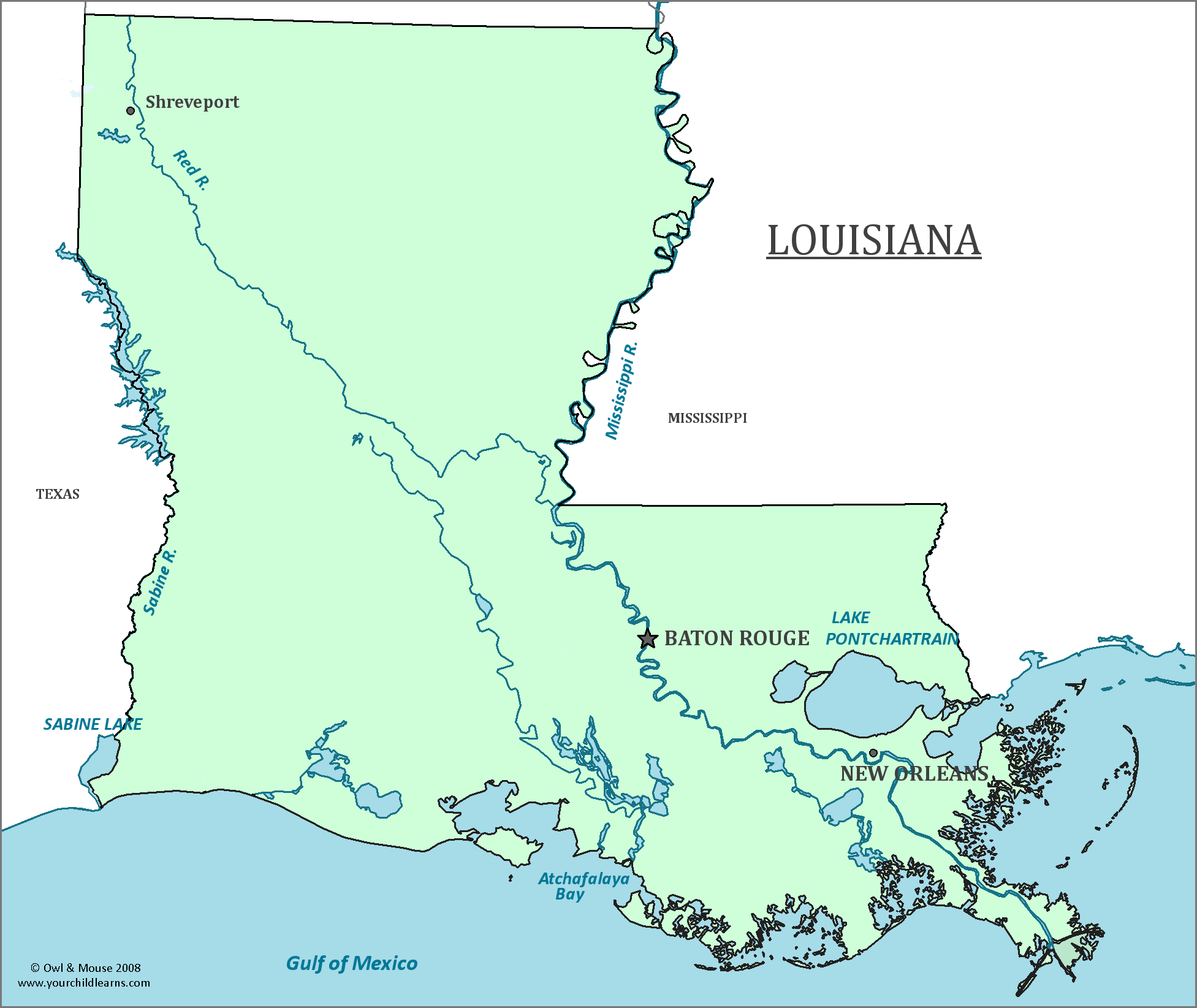
Louisiana
Louisiana, the state which contains New Orleans and the southern part of the Mississippi River, still shows many aspects its French heritage. The outline of the state resembles a boot.
Date first visited by Europeans: Panfilo de Narváez, a Spanish explorer, led an expedition in 1528 to the mouth of the Mississippi, which is now the city of New Orleans.
Date admitted to US: 1812
Date seceded: 1861
Date readmitted to US: 1862 (partial), 1865 (complete).
Capital: Baton Rouge
Largest City: New Orleans
Terrain: Northern Louisiana resembles neighboring Texas and Arkansas, with hilly uplands. Driskill Mountain, is the highest point of the state, and is located in these uplands. It is only 535 feet above sea level, but New Orleans, the lowest point in the state, is actually 8 feet below sea level.
The southern part of the state is flatter then the north, and is home to many rivers, streams, and wetlands. It is also home to the largest river delta in the United States, the Mississippi River Delta (Not to be confused with the Mississippi Delta).
Area: 51,843 sq mi
Area Rank: 31st
Population:4, 649,676
Population rank: 25th
Electoral Votes: 8
The United States purchased the whole of the Louisiana Territory from France in 1803. The name was given to the state, but the Louisiana Territory included land that would become other statues such as Missouri, Arkansas , Texas, Iowa, Kansas, Colorado, South and North Dakota, and even as far north as Nebraska and Canada.
The French Pirate Jean Laffite (Spelled Lafitte in English documents) was based in Louisiana. He was captured, but was offered a pardon by President Andrew Jackson if he helped to defend Louisiana from the British in the war of 1812. Jackson was initially reluctant to trust the pirate and his band of smugglers, but then realized that the critical port of New Orleans was defended by only a thousand untrained men and two ships. The pirates, including Jean Laffite and his brother Pierre were pardoned after fighting in defense of the port. After only a couple of years of receiving the pardon the two brothers later resumed their smuggling.
Louisiana did not rejoin the Union all at once after the secession of the Confederate States of America. New Orleans was an important port, and the Union wanted to control the Mississippi river for transport and to divide the Confederacy. Furthermore, Major General Butler, a controversial figure, was given command of the city and rallied poor whites and poor blacks who had little economic reason to support slavery to help the Union, preventing a popular uprising. Various areas of Louisiana controlled by Federal troops were declared to be a state within the Union, and allowed their own elected officials in the US Congress.
In New Orleans, the Mardi Gras celebration is famous for parades, food, drink, parties and outrageous costumes. It is derived from the Catholic celebration of Carnival, which is a party before the observance of Lent, where many Catholics, Lutherans, Anglicans and other sects of Christianity do ritual fasting or otherwise refrain from certain indulgences. Carnival therefore is one last party before this solemn time.
The first recorded celebration of Mardi Gras was in 1699, but as many settlers in the region had a strong French and Catholic influence it is unlikely this was the first such celebration. In 1875 Mardi Gras was declared to be a state holiday for Louisiana, and has been celebrated ever since. Some parades, however, were suspended during both World War I and World War II.
Various 'Krewes' (pronounced just like 'crew'), or social clubs, obtain permits to hold gaudy and spectacular parades in the city of New Orleans during Mardi Gras. Several costume contests are also held across the city, along with lavish balls that many people have tried to crash or even obtain the old invitations for.
Print this map of the United States US States and Capitals Map Quiz
Free Maps, Map Puzzles and Educational Software: Owl and Mouse Educational Software
