
Print this map of Nicaragua US States and Capitals Map Quiz
Free Maps, Map Puzzles and Educational Software: Owl and Mouse Educational Software
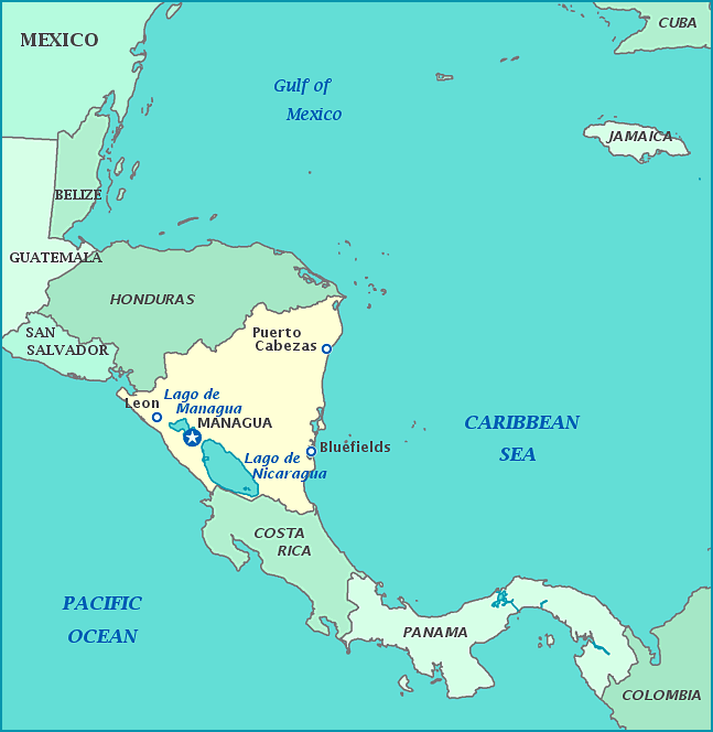
Nicaragua
Originally called Nicarao by the native tribes of Niquirano, Chartegano, and Chontal, the Republic of Nicaragua is the largest country in the Central American Isthmus. In the 16th century it was discovered by the Spanish and the first attempt to conquer the land was in 1520. It would be 4 years until the first settlement would begin. The land was parceled out to conquistadors, all of whom wanted the fertile western region. Because such elite refused to do manual labor, most of the natives who weren't killed in the invasion or by diseases the Spanish had accidentally brought with them, were enslaved to work long hours on the new plantations. A few were spared this fate, only to be forced to work in even more primitive conditions in mines. As of 1538, Nicaragua was incorporated into the Viceroyalty of New Spain, along with most other future countries in Central America and in 1570, it became part of the autonomous Captaincy of Guatemala.
The country gained Independence in 1821, though only after suffering a long string of bad fortune. In 1610, the volcanic eruption destroyed the capital, forcing the city to rebuild entirely. The country was full of rebellious attitudes, from minor though frequent rebellions that had to be repressed, to raids by Dutch pirates, to being caught between Spain's forces and Britain's in the Caribbean, British Honduras, and the American colonies during the American Revolutionary War. Britain claimed the Mosquito coast as a protectorate in 1650
Despite independence 17 years earlier, Nicaragua remained conjoined with other countries until 1838. Later in the century, other countries began to interfere with the new country, for better and for worse. In 1859, Britain ceded the coast to Nicaragua, the handover officially in 1860, though the coast ruled itself until 1894. The next century saw US interest in the country. American corporations bought up land for plantations and used the money to influence the Nicaraguan government until the people refused to allow the US to steal and run their country forcing many into low pay. Violent guerrilla protests began. Despite the US army's attempt to repress the rebellions, riots, and protests, their frequency did much to halt and hinder the corporations. President Zelaya eventually had two Americans executed for planting mines in the San Juan River. This led to the Banana wars in 1912, lasting until 1933 with the US occupying Nicaragua. Finally, the US withdrew, only due to their own economic recession known as the Great Depression and not due in part to the Nicaraguan forces.
The US did not give up and returned with more sinister plans. The Somoza family was installed by US political engineering, and the family began their tyrannical legacy in 1929, and would be the longest running hereditary dictatorship in the history of the country. Through them the US eliminated the need to send in US marines and could now heavily influence Nicaragua's military and give favors to US corporations. Nicaragua declared war on Germany during WWII, though soldiers were not sent and no fighting commenced; however, the government did use the war as an excuse to take property from German citizens. Again, anti-US sentiment began to boil over and became more than armed forces could handle, this time sparking the Nicaraguan Civil War from 1961. The Somozas' reign ended in 1979 and the War in 1990.
Nicaragua's name derives from the many lakes, including the two largest freshwater lakes in Central America: Lake Managua and Lake Nicaragua. Along with the lakes, the country is also home to many volcanoes, most of which are still active today. While beautiful and lush, it is one of the poorest countries in both Americas and 69.4% of the population lives in poverty.
Area: 130,370 square kilometers
Population: 5,907,881
