More
Map Puzzles!
Owl and Mouse Educational Software Page
Click Here
Find more FREE Educational Software
at the
Owl and Mouse Educational Software Page
Click Here
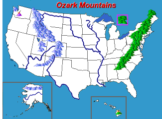
US Physical Features Map
Learn US Geography with a fun, hands-on paste up map
|
|
 You
can give your children the geographical framework that will help them
understand so much else that they study, with free interactive maps.
Geography is spatial, why not study it spatially? You
can give your children the geographical framework that will help them
understand so much else that they study, with free interactive maps.
Geography is spatial, why not study it spatially?
The heart of geography, and even the source
of its name is the map—a picture of the world which organizes our
understanding of places. Manipulating a map, assembling it, is the
best way to learn where features are, and how near or far they are to
each other. The map is a framework that brings other knowledge
together and makes the world understandable.
The "what?"
and the "where?" are a necessary beginning to understanding
the "who?" and the "why?"
Here are the major
rivers, mountains, deserts and rainforests that have influenced and
continue to influence where and how human beings live in the United
States.
Students need not just names, but a permanent picture of the world in
their minds. Geography is real places, and a map represents those
places much better than words can. Knowing where the Mojave Desert, the
Arkansas River, the Ozark Mountains are helps to orient a student
in the country in a meaningful way.
Free! Play United
States Features Puzzle online
|
 |
|
You might also be interested
in:
MegaMaps - Walk Through the
Continents
Print U.S.
and World maps from a single page to 8 pages (nearly 7
feet across). Large maps to learn geography, to color for
fun, or to put together as a puzzle. This is a fun way to
learn the states, their capitals and foreign countries.
Great for classrooms and homeschool. Free Software.
Interactive Map of Asia
On-line interactive map of Asian borders, countries, capitals and
surroundings.
|